Many schools have what is termed ‘a local-intake area’. Due to ongoing enrolment pressures Gosnells Primary School no longer has a local-intake area.
As a school without a local-intake area, the Principal will:
- assess all enrolment applications;
- give enrolment priority to students from those living nearest to the school to those living furthest from the school; and
- give preference to families who already have a child enrolled with us.
Being a school without a local-intake area means that if a parent/guardian is seeking to enrol their child into a year level that is at capacity a placement will not be offered.
Gosnells Primary School does however have ‘optional local-intake areas’. Given our current enrolment pressures it would be recommended that parents/guardians consider one of the other optional schools which may have smaller class sizes.
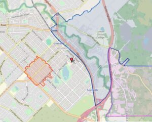
Shaded areas on the map below indicate these optional local-intake areas.
Please refer to the map description below for further details.
GOSNELLS PRIMARY SCHOOL (5192) (Government Gazette December 1995)
The following defines the optional local-intake areas of this school:
The following is an optional area for Gosnells and East Maddington Primary Schools:
From the eastern extremity of Rushton Road, west and northwest along Rushton Road to Ellis Brook, in a general westerly direction along Ellis Brook to Mills Road West, northwest along Mills Road West to Gosnells Road, west along Gosnells Road to Albany Highway, south along Albany Highway to Fremantle Road, west along Fremantle Road to the railway line, southeast and south along the railway line to a point due west of the junction of Albany Highway and Tonkin Highway, east from this point to Tonkin Highway, northeast along Tonkin Highway to Mills Road East, east along Mills Road East to Pages Way and due east from this point.
The boundary parts of Rushton Road (both sides), Albany Highway (both sides), Fremantle Road (both sides), and Tonkin Highway (west side) are included within the optional area, while the boundary parts of Mills Road West (both sides), Gosnells Road (both sides) and Mills Road East (both sides) are excluded from the optional area.
The following is an optional area for Gosnells and Clifton Hills Primary Schools:
From the junction of Mills Road East and Tonkin Highway, southwest along Tonkin Highway to the Canning River, south along the Canning River to the boundary between the City of Gosnells and the City of Armadale, in a general easterly direction along this boundary to the western site boundary of Cohuna Wildlife Sanctuary, north from this point to a point due east of the junction of Mills Road East and Pages Way, west from this point to the junction of Mills Road East and Pages Way and west along Mills Road to Tonkin Highway.
The boundary parts of Tonkin Highway (southeast side) and Mills Road East (both sides) are included within the optional area.
The school also has an optional intake area as declared under Ashburton Drive Primary School and defined below.
The following defines an optional area between Ashburton Drive, Gosnells, Seaforth and Wirrabirra Primary Schools:
The area bounded by Corfield Street, Goodall Street, Eudoria Street and Stalker Road. The boundary parts of the four boundary streets are included within this optional area.
Note: The local-intake area maps are based on a written description of the local-intake area (LIA) for the school as published in the WA Government Gazette. Although the map closely represents the LIA description, for some houses near the boundary (especially on street corners), it may be necessary to refer to the written description. The street address of a residence is used to determine whether that dwelling is inside a particular LIA. While local-intake areas for most schools do not change from year to year, changes may be made to local-intake areas as required. Such changes are published in the WA Government Gazette and subsequently the local-intake area map will be updated.


